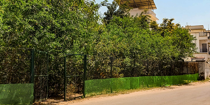
Planting trees in an urban area may look…
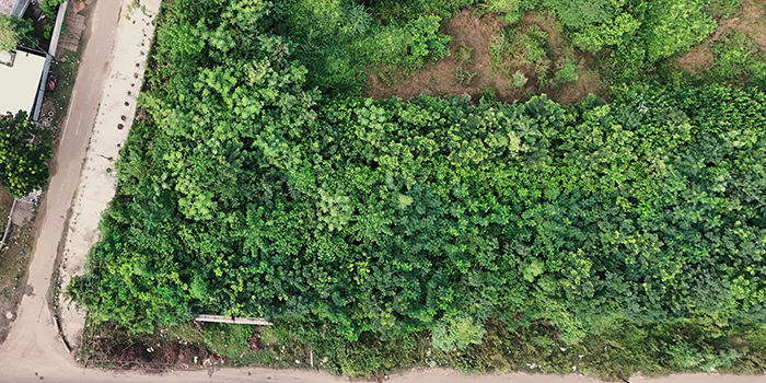
Urban Biodiversity Mapping: Identifying Ecological Restoration Sites
A city is not just structures, roads, and other infrastructures. There are still parts of nature like trees, gardens, wetlands, green spaces, roadside flora, and other small habitats that make up the ecology of the city.
However, such natural spaces are never equally distributed throughout a city. While some areas in the city have developed vegetation and habitats, other areas could be bare of any green cover and have land that is either degraded or fragmented into green spaces. More planting will not solve this problem.
Urban biodiversity mapping provides a way to understand this ecological variation before restoration decisions are made.
The components include the identification of flora, habitats, ecological factors, as well as the existence of biodiversity within the selected region. These help in identifying any natural resources, ecological gaps, as well as areas that need to be restored.
Rather than asking only where trees can be planted, biodiversity mapping helps answer a broader question: where can ecological restoration create meaningful environmental value?
What Is Urban Biodiversity Mapping?
Biodiversity Mapping in Urban Areas, This refers to the identification of natural features within the urban landscape. The elements identified will depend on the reasons for undertaking the survey. Vegetation, trees, habitats, water bodies, wildlife sightings and others could be included.
It helps in gaining a better understanding of the presence of natural features within the built-up area. It shows areas where there is vegetation that has been established, fragmentation of habitats and few ecological features.
For example, two open areas may appear similar from a distance, but one may contain mature native vegetation while the other may have poor soil and little ecological value. Mapping can help identify these differences before restoration work begins.
This is why the aim is not just to create a map of the green spaces. Rather, the aim is to give ecological data that will inform good planning and conservation decision-making.
Creating a Biodiversity Baseline
A reliable restoration strategy begins with understanding what is already present.
The baseline for biodiversity is when there is documentation of the ecosystem attributes prior to any major activity occurring. This could include anything from the presence of trees to types of vegetation and water features.
The information will help in determining which regions need protection and which regions need restoration. The information will also give a baseline for comparison once the ecological processes have been completed.
For an urban landscape, this baseline can be especially useful because development pressure may have created significant differences between neighbouring sites. Recording these conditions gives planners a stronger foundation for deciding where attention is needed.
Identifying Existing Ecological Assets
Urban biodiversity is often present in places that are not formally recognized as ecological spaces.
A mature tree along a road, a group of native plants beside a water body, an old vegetation patch or a small undeveloped area can provide food, shelter and habitat for different organisms.
Biodiversity mapping can identify these existing assets before landscape changes or restoration activities are planned. Protecting established ecological features can sometimes provide greater value than removing them and replacing them with new plantation.
This makes mapping useful not only for finding restoration sites but also for identifying natural features that should be retained and incorporated into future landscape planning.
Finding Ecological Gaps
An urban area can have plenty of greenery and still contain significant biodiversity gaps.
For example, a landscape may have large lawns but very little native vegetation. Another location may have trees but limited ground cover or habitat diversity. Some green spaces may also be isolated from other natural areas.
Mapping can help identify these gaps by examining factors such as:
- Limited native vegetation
- Fragmented habitat areas
- Poorly connected green spaces
- Low vegetation diversity
- Areas with limited tree cover
- Degraded or disturbed land
- Lack of suitable habitat features
- Locations with restoration potential
This strategy changes the emphasis from just increasing the number of plantations to tackling particular ecological weaknesses in the landscape.
Prioritising Potential Restoration Sites
All available land does not need to be turned into plantation land.
The suitability of any proposed land for restoration depends on its current ecology, surrounding land use, availability of water, accessibility and future landscaping needs.
Urban biodiversity mapping can help bring these factors together so that restoration opportunities can be compared more systematically.
Some locations may require habitat enhancement, while others may benefit from native plantation, vegetation recovery or ecological landscape development. In this way, site selection becomes connected to environmental conditions rather than being based only on land availability.
Understanding Habitat Connectivity
Ecological value is influenced not only by individual green spaces but also by how those spaces connect with one another.
Roads, buildings and other forms of development can divide habitats into smaller and more isolated patches. Mapping can reveal where these breaks occur and where existing vegetation may provide connections between different ecological areas.
Trees along roads, vegetation near waterways, parks and institutional green spaces can sometimes form links between otherwise separated habitats.
Understanding these relationships can support the development of connected green networks. Instead of treating every plantation as a separate project, ecological planning can consider how different green areas contribute to the wider urban landscape.
Assessing Native Vegetation
Trees do not necessarily mean there is high biodiversity.
It is equally important to consider the species, their ecological function and how they relate to other plants around them. Through biodiversity mapping, you can identify any native vegetation present and where the vegetation is not very diverse.
This information can support more suitable planting decisions during restoration. Native trees, shrubs and ground vegetation can be selected according to site conditions and their potential contribution to the local ecological system.
Fast growing trees may provide rapid vegetation development in certain situations, but growth speed should not be the only consideration. Species suitability, ecological function and long-term landscape requirements also need to be considered.
Considering Soil and Site Conditions
Ecological restoration cannot be separated from the physical condition of the site.
Urban land may have experienced construction activity, compaction, erosion or loss of organic matter. These conditions can affect vegetation establishment and influence the type of restoration that a site can support.
A biodiversity assessment can therefore be complemented by an understanding of soil and site conditions. Areas requiring soil improvement can be identified, while locations with healthy established vegetation may be better suited to conservation and minimal intervention.
This helps connect biodiversity planning with practical site preparation and landscape restoration.
Using Mapping for Urban Forest Planning
Urban biodiversity mapping can support the planning of an urban forest by showing how proposed tree-based areas relate to existing ecological features.
Instead of developing an isolated plantation, planners can consider surrounding vegetation, habitat connections, open spaces and existing natural assets.
Tree density can also be considered as part of this broader assessment. The objective should not simply be to maximize the number of trees but to develop vegetation that is appropriate for the available space and ecological purpose.
Depending on the site, restoration may involve an urban forest, native woodland, green corridor, biodiversity zone or another suitable landscape intervention.
Selecting the Right Restoration Approach
Biodiversity mapping does not automatically point toward one particular restoration technique.
A site with sufficient space and suitable conditions may support native tree plantation. Another may be more appropriate for habitat enhancement or a green corridor. In some locations, a Miyawaki method forest could be considered where dense native plantation is suitable for the site.
The important point is that the restoration approach should follow the assessment rather than the other way around.
By understanding the ecological characteristics of each location, planners can select an intervention that matches the site’s environmental conditions, surrounding landscape and long-term purpose.
From Mapping to Landscape Planning
The real value of biodiversity mapping comes when the information is used for practical planning.
The findings can help guide decisions about which areas should be protected, where restoration is required and how new vegetation can be connected with existing ecological features.
It can also help landscape planning move beyond appearance-based decisions. Trees, habitats, open spaces, soil and water features can be considered as connected components of the same environmental system.
This creates opportunities for landscapes that provide ecological value while still fitting within the functional requirements of an urban area.
Monitoring Ecological Change
Mapping can also establish a useful reference for future monitoring.
Urban landscapes continue to change as vegetation grows, new development occurs and restoration areas mature. Repeating assessments can help identify changes in vegetation cover, habitat connectivity, native species presence and other ecological conditions.
Monitoring may consider:
- Changes in vegetation cover
- Development of native plant communities
- Expansion or improvement of habitat areas
- Changes in green-space connectivity
- Growth of restored vegetation
- Changes in ecological site conditions
This creates a more measurable approach to restoration and helps organizations understand how an ecological project develops over time.
Supporting Environmental CSR Projects
For organizations planning environmental corporate social responsibility CSR initiatives, biodiversity mapping can provide a more informed starting point.
Instead of selecting plantation locations only because they are available or easily accessible, organizations can assess ecological conditions and identify areas where environmental intervention may be meaningful.
A CSR initiative may then support native plantation, habitat restoration, green-space connectivity or recovery of degraded areas according to the needs of the selected site.
The mapping process can also provide baseline information that helps document the condition of an area before and after the project.
The Role of Carbon in Restoration Planning
Tree-based ecological restoration can contribute to carbon sequestration, but biodiversity mapping itself should not be treated as a carbon credit activity.
The primary purpose of mapping is to understand ecological conditions and identify suitable restoration opportunities. Where carbon objectives are part of a wider environmental project, vegetation planning can consider carbon sequestration alongside biodiversity, habitat and landscape outcomes.
Any carbon credit or carbon offset claim requires appropriate project methodology, measurement and verification. Keeping these objectives distinct helps ensure that ecological restoration is evaluated on more than carbon numbers alone.
How Harmony Urban Forest Can Support Restoration Planning
Ecological restoration needs to begin with a full knowledge of the area prior to planting.
Harmony Urban Forest is in a position to assist organizations and individuals develop environmentally friendly plantation and urban green space initiatives, taking into account the existing environment, flora, site, and ecological goals.
Biodiversity-focused planning can help identify where restoration may be appropriate and how new vegetation can complement existing green areas. Depending on site requirements, the resulting project may involve native plantation, an urban forest or another suitable ecological landscape approach.
This type of planning allows environmental initiatives to be connected with the actual characteristics of the site rather than following the same plantation model everywhere.
Conclusion
Urban biodiversity mapping provides a structured way to understand the ecological character of developed landscapes before restoration decisions are made.
By identifying existing ecological assets, biodiversity gaps, fragmented habitats, native vegetation and potential restoration areas, mapping can support more informed approaches to urban ecological planning.
It also helps connect different considerations such as tree density, soil condition, habitat connectivity and landscape requirements. Instead of measuring success only through the number of trees planted, restoration can be planned around the wider ecological value of the site.
Different locations may require different approaches. Some may benefit from native plantation or an urban forest, while others may need habitat enhancement, green corridors or protection of existing vegetation. A Miyawaki method forest can be considered where its characteristics are appropriate, but it should remain one option within a broader restoration strategy.
For organizations developing corporate social responsibility CSR environmental initiatives, biodiversity mapping can provide a useful baseline for selecting sites and monitoring ecological changes. Where carbon objectives are included, they can be considered alongside biodiversity and landscape outcomes through appropriate carbon project processes.
Ultimately, urban biodiversity mapping helps answer an important question before restoration begins: what does this landscape need?
Understanding that need can lead to better site selection, more suitable ecological interventions and urban green spaces that provide value beyond simply adding more trees.
FAQs
1. What is urban biodiversity mapping?
Urban biodiversity mapping is the process of identifying and documenting ecological features within an urban area. It can include trees, vegetation, habitats, green spaces, water features and other natural elements. The information helps identify ecological assets, biodiversity gaps and locations where restoration or conservation may be appropriate.
2. Why is urban biodiversity mapping important before restoration?
Mapping provides information about the existing condition of a landscape before restoration begins. It can identify valuable vegetation that should be protected, areas with ecological gaps and locations where habitats are fragmented. This helps restoration planning respond to actual site conditions instead of selecting locations only according to available land.
3. Can biodiversity mapping help identify ecological restoration sites?
Yes. Biodiversity mapping can highlight degraded areas, habitat gaps, poorly connected green spaces and locations with restoration potential. These findings can then be combined with site-specific information such as soil, water availability, infrastructure and surrounding land use to determine which restoration approach may be suitable.
4. Does urban biodiversity mapping only identify trees?
No. Trees are only one component of an urban biodiversity assessment. Depending on the purpose of the study, mapping can consider shrubs, ground vegetation, habitats, water features, wildlife observations and other ecological elements. Looking at these components together provides a broader understanding of the urban ecological landscape.
5. How does biodiversity mapping support urban forest planning?
Biodiversity mapping can show how proposed tree-based restoration areas relate to existing vegetation, habitats and green spaces. This helps planners consider connectivity, site conditions and ecological purpose while planning an urban forest rather than focusing only on the number of trees that can be planted.
6. Does tree density determine biodiversity?
No. Tree density is only one consideration in biodiversity planning. Species diversity, vegetation structure, soil conditions, habitat quality and connectivity can also influence ecological value. A site with many trees may still have limited biodiversity if vegetation is highly uniform or habitat features are lacking.
7. Can biodiversity mapping identify areas for native tree plantation?
Yes. Mapping can help identify areas where native vegetation is limited and where ecological restoration may be appropriate. However, species selection should also consider site conditions, soil, water availability, surrounding vegetation and the long-term purpose of the landscape.
8. Is the Miyawaki method suitable for every restoration site?
No. A Miyawaki method forest is one possible approach for suitable sites, particularly where dense native plantation is appropriate. Other locations may be better suited to native woodland, green corridors, habitat restoration or different landscape interventions. Site assessment should guide the choice of restoration method.
9. Can biodiversity mapping support corporate social responsibility CSR projects?
Yes. Biodiversity mapping can help organizations understand ecological conditions before investing in environmental CSR initiatives. It can support the identification of restoration opportunities and provide baseline information for monitoring changes after plantation, habitat restoration or other ecological activities.
10. Can Harmony Urban Forest help with ecological restoration planning?
Harmony Urban Forest can support organizations in planning urban green-space and ecological plantation projects based on site conditions and environmental objectives. The planning approach can consider existing vegetation, ecological requirements and the wider landscape to help develop restoration initiatives that are suited to the selected site.
Related Posts